
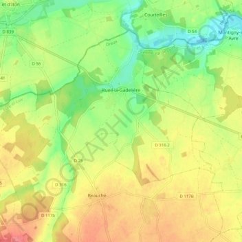
Rueil-la-Gadelière topographic map
Interactive map
Click on the map to display elevation.
About this map
Name: Rueil-la-Gadelière topographic map, elevation, terrain.
Average elevation: 577 ft
Minimum elevation: 459 ft
Maximum elevation: 699 ft
Other topographic maps
Click on a map to view its topography, its elevation and its terrain.
Les Épinolières
France > Centre-Val de Loire > Eure-et-Loir > Charbonnières
Les Épinolières, Charbonnières, Nogent-le-Rotrou, Eure-et-Loir, Centre-Val de Loire, Metropolitan France, 28330, France
Average elevation: 735 ft
Dreux
France > Centre-Val de Loire > Eure-et-Loir
Dreux, Eure-et-Loir, Centre-Val de Loire, Metropolitan France, 28100, France
Average elevation: 371 ft
Luray
France > Centre-Val de Loire > Eure-et-Loir
Luray, Dreux, Eure-et-Loir, Centre-Val de Loire, Metropolitan France, 28500, France
Average elevation: 410 ft
Épernon
France > Centre-Val de Loire > Eure-et-Loir
Épernon, Chartres, Eure-et-Loir, Centre-Val de Loire, Metropolitan France, 28230, France
Average elevation: 463 ft
Nogent-le-Rotrou
France > Centre-Val de Loire > Eure-et-Loir
Nogent-le-Rotrou, Eure-et-Loir, Centre-Val de Loire, Metropolitan France, 28400, France
Average elevation: 476 ft