
Wolayita topographic map
Interactive map
Click on the map to display elevation.
About this map
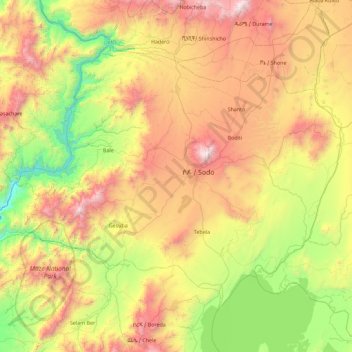
Name: Wolayita topographic map, elevation, terrain.
Location: Wolayita, Southern Nations, Ethiopia (6.51167 37.22512 7.19096 38.13343)
Average elevation: 5,207 ft
Minimum elevation: 2,221 ft
Maximum elevation: 9,780 ft
Other topographic maps
Click on a map to view its topography, its elevation and its terrain.
Worabe
Ethiopia > Southern Nations > Worabe
Worabe, Guraghe, Southern Nations, Ethiopia
Average elevation: 6,936 ft
Gidole
Ethiopia > Southern Nations > Gidole
Gidole, Derashe Special Woreda, Southern Nations, Ethiopia
Average elevation: 6,647 ft
Durame
Ethiopia > Southern Nations > Durame
Durame, Kembata Alaba Tembaro, Southern Nations, Ethiopia
Average elevation: 7,037 ft
Bona Qabelanka
Ethiopia > Southern Nations > Bona Qabelanka
Bona Qabelanka, Sidama, Southern Nations, Ethiopia
Average elevation: 6,880 ft
Kombo
Ethiopia > Southern Nations > Kombo
Kombo, Guraghe, Southern Nations, Ethiopia
Average elevation: 9,341 ft
Baja'I
Baja'I, Guraghe, Southern Nations, Ethiopia
Average elevation: 7,129 ft
Elma
Elma, South Omo, Southern Nations, Ethiopia
Average elevation: 2,300 ft
Yirga Ch'Efe Bota
Ethiopia > Southern Nations > Yirga Cheffe
Yirga Ch'Efe Bota, Yirga Cheffe, Gedeo, Southern Nations, Ethiopia
Average elevation: 7,329 ft
Kasha
Ethiopia > Southern Nations > Kasha
Kasha, Keffa, Southern Nations, Ethiopia
Average elevation: 5,722 ft