
Lafayette topographic map
Interactive map
Click on the map to display elevation.
About this map
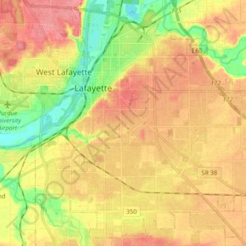
Name: Lafayette topographic map, elevation, terrain.
Location: Lafayette, Tippecanoe County, Indiana, United States (40.35549 -86.92611 40.45305 -86.79032)
Average elevation: 633 ft
Minimum elevation: 499 ft
Maximum elevation: 735 ft
Lafayette is located at 40°24′38″N 86°52′29″W / 40.410585°N 86.874681°W / 40.410585; -86.874681 (40.410585, −86.874681) and is located in Fairfield and Wea Townships. Elevation at the court house is 550 feet (168 m), but city elevations range from a little over 500 feet (150 m) at the Wabash River to approximately 700 feet (210 m) in the areas of Murdock Park and Columbian Park.
Other topographic maps
Click on a map to view its topography, its elevation and its terrain.
West Lafayette
United States > Indiana > Tippecanoe County
West Lafayette, Tippecanoe County, Indiana, United States
Average elevation: 630 ft
Burnett's Creek
United States > Indiana > Tippecanoe County > Battle Ground
Burnett's Creek, Battle Ground, Tippecanoe County, Indiana, United States
Average elevation: 587 ft
Battle Ground
United States > Indiana > Tippecanoe County
Battle Ground, Tippecanoe County, Indiana, United States
Average elevation: 591 ft
Altamont Switch
United States > Indiana > Tippecanoe County > Lafayette
Altamont Switch, Lafayette, Tippecanoe County, Indiana, 47909, United States
Average elevation: 646 ft
Buck Creek
United States > Indiana > Tippecanoe County
Buck Creek, Tippecanoe County, Indiana, 47924, United States
Average elevation: 663 ft
West Point
United States > Indiana > Tippecanoe County
West Point, Tippecanoe County, Indiana, 47992, United States
Average elevation: 650 ft