
Clacton-on-Sea topographic map
Interactive map
Click on the map to display elevation.
About this map
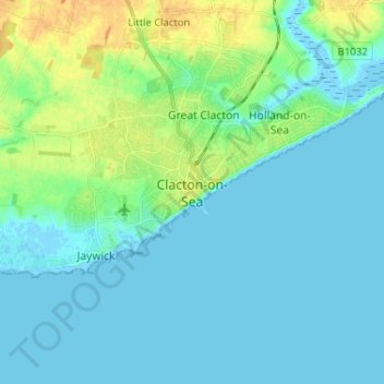
Name: Clacton-on-Sea topographic map, elevation, terrain.
Average elevation: 23 ft
Minimum elevation: -10 ft
Maximum elevation: 92 ft
Other topographic maps
Click on a map to view its topography, its elevation and its terrain.
Harwich
United Kingdom > England > Essex > Tendring
Harwich, Tendring, Essex, England, United Kingdom
Average elevation: 3 ft
Dovercourt
United Kingdom > England > Essex > Tendring
Dovercourt, Tendring, Essex, England, CO12 3RG, United Kingdom
Average elevation: 13 ft