
Halawa topographic map
Interactive map
Click on the map to display elevation.
About this map
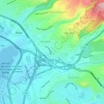
Name: Halawa topographic map, elevation, terrain.
Average elevation: 259 ft
Minimum elevation: -3 ft
Maximum elevation: 1,007 ft
The route of H-3 extends from its western terminus with east–west Moanalua Freeway (H-201; connecting eastward to Honolulu or westward to H-1 and Aiea) to the 1100-foot (335-m) elevation entrance into the Tetsuo Harano Tunnels, penetrating the Ko‘olau crest. The freeway continues beyond to Kaneohe on windward Oahu.
Other topographic maps
Click on a map to view its topography, its elevation and its terrain.
Hickam Housing
United States > Hawaii > Honolulu County > Waipahu
Hickam Housing, Hickam, Aiea, Honolulu County, Hawaii, United States
Average elevation: 16 ft
Joint Base Pearl Harbor-Hickam
United States > Hawaii > Honolulu County > Waipahu
Joint Base Pearl Harbor-Hickam, Waipahu, Honolulu County, Hawaii, 96853, United States
Average elevation: 23 ft
USS Utah
United States > Hawaii > Honolulu County > Waipahu
USS Utah, Waipahu, Honolulu County, Hawaii, United States
Average elevation: 7 ft