
Arklow topographic map
Interactive map
Click on the map to display elevation.
About this map
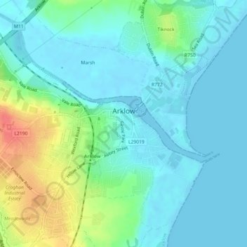
Name: Arklow topographic map, elevation, terrain.
Average elevation: 46 ft
Minimum elevation: -3 ft
Maximum elevation: 184 ft
Other topographic maps
Click on a map to view its topography, its elevation and its terrain.
Kiltegan
Kiltegan, The Municipal District of Baltinglass, County Wicklow, Leinster, Ireland
Average elevation: 492 ft
Upper Lake
Upper Lake, Brockagh ED, The Municipal District of Wicklow, County Wicklow, Leinster, Ireland
Average elevation: 1,086 ft
The Municipal District of Baltinglass
The Municipal District of Baltinglass, County Wicklow, Leinster, Ireland
Average elevation: 597 ft
Calary
Calary, County Wicklow, Leinster, A98 KN50, Ireland
Average elevation: 968 ft
Enniskerry
Enniskerry, Enniskerry ED, The Municipal District of Bray, County Wicklow, Leinster, Ireland
Average elevation: 341 ft
The Municipal District of Bray
The Municipal District of Bray, County Wicklow, Leinster, Ireland
Average elevation: 928 ft
The Municipal District of Wicklow
The Municipal District of Wicklow, County Wicklow, Leinster, Ireland
Average elevation: 863 ft
Greystones
Ireland > County Wicklow > Greystones
Greystones, The Municipal District of Greystones, County Wicklow, Leinster, A63 HW80, Ireland
Average elevation: 161 ft