
Port Mansfield topographic map
Interactive map
Click on the map to display elevation.
About this map
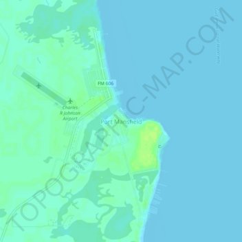
Name: Port Mansfield topographic map, elevation, terrain.
Location: Port Mansfield, Willacy County, Texas, 78598, United States (26.53479 -97.44498 26.57479 -97.40498)
Average elevation: 10 ft
Minimum elevation: -3 ft
Maximum elevation: 36 ft
Other topographic maps
Click on a map to view its topography, its elevation and its terrain.
Padre Island National Seashore
United States > Texas > Willacy County > Corpus Christi
Padre Island National Seashore, Corpus Christi, Willacy County, Texas, 78418, United States
Average elevation: 16 ft
Raymondville
United States > Texas > Willacy County
Raymondville, Willacy County, Texas, 78580, United States
Average elevation: 39 ft