
Havre topographic map
Interactive map
Click on the map to display elevation.
About this map
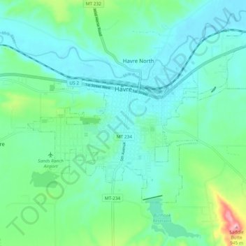
Name: Havre topographic map, elevation, terrain.
Location: Havre, Hill County, Montana, United States (48.52507 -109.71424 48.56529 -109.62067)
Average elevation: 2,589 ft
Minimum elevation: 2,457 ft
Maximum elevation: 3,104 ft
Other topographic maps
Click on a map to view its topography, its elevation and its terrain.
Cement Hill
United States > Montana > Hill County
Cement Hill, Hill County, Montana, United States
Average elevation: 2,894 ft
Rocky Boy's Agency
United States > Montana > Hill County > Rocky Boy's Agency
Rocky Boy's Agency, Hill County, Montana, United States
Average elevation: 3,930 ft
Havre
United States > Montana > Hill County > Havre
Havre, Hill County, Montana, 59501, United States
Average elevation: 2,785 ft