
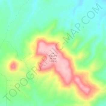
Square Butte topographic map
Interactive map
Click on the map to display elevation.
About this map
Name: Square Butte topographic map, elevation, terrain.
Average elevation: 2,900 ft
Minimum elevation: 2,641 ft
Maximum elevation: 3,310 ft
Other topographic maps
Click on a map to view its topography, its elevation and its terrain.
Forman
United States of America > North Dakota > Forman
Forman, Sargent County, North Dakota, 58032, United States of America
Average elevation: 1,257 ft
Tongue River
United States of America > North Dakota
Tongue River, Pembina County, North Dakota, United States of America
Average elevation: 804 ft
Parshall
United States of America > North Dakota > Parshall
Parshall, Mountrail County, North Dakota, United States of America
Average elevation: 1,962 ft
Pillsbury
United States of America > North Dakota > Pillsbury > Pillsbury
Pillsbury, Barnes County, North Dakota, United States of America
Average elevation: 1,273 ft