
Litchfield topographic map
Interactive map
Click on the map to display elevation.
About this map
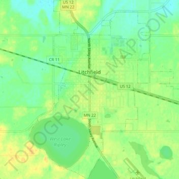
Name: Litchfield topographic map, elevation, terrain.
Location: Litchfield, Meeker County, Minnesota, 55355, United States (45.09486 -94.55378 45.14887 -94.48791)
Average elevation: 1,129 ft
Minimum elevation: 1,089 ft
Maximum elevation: 1,171 ft
Other topographic maps
Click on a map to view its topography, its elevation and its terrain.
Jennie
United States > Minnesota > Meeker County
Jennie, Collinwood Township, Meeker County, Minnesota, United States
Average elevation: 1,093 ft
Kingston
United States > Minnesota > Meeker County
Kingston, Meeker County, Minnesota, United States
Average elevation: 1,060 ft
North Side Mobile Home Park
United States > Minnesota > Meeker County > Grove City
North Side Mobile Home Park, Grove City, Meeker County, Minnesota, 56243, United States
Average elevation: 1,191 ft
Dassel
United States > Minnesota > Meeker County
Dassel, Meeker County, Minnesota, 55325, United States
Average elevation: 1,093 ft