
Whittier topographic map
Interactive map
Click on the map to display elevation.
About this map
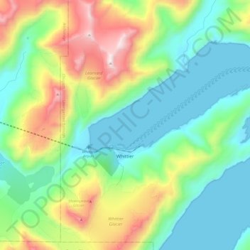
Name: Whittier topographic map, elevation, terrain.
Location: Whittier, Chugach, Alaska, 99693, United States (60.76259 -148.74646 60.81248 -148.50805)
Average elevation: 1,332 ft
Minimum elevation: -13 ft
Maximum elevation: 4,616 ft
Other topographic maps
Click on a map to view its topography, its elevation and its terrain.
Prince William Sound
United States > Alaska > Chugach
Prince William Sound, Chugach, Alaska, United States
Average elevation: 0 ft
Sherman Glacier
United States > Alaska > Chugach
Sherman Glacier, Chugach, Alaska, United States
Average elevation: 2,464 ft