
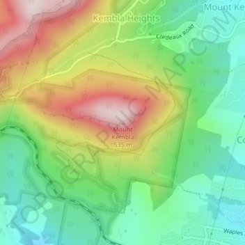
Mount Kembla topographic map
Interactive map
Click on the map to display elevation.
About this map
Name: Mount Kembla topographic map, elevation, terrain.
Average elevation: 745 ft
Minimum elevation: 98 ft
Maximum elevation: 1,732 ft
The summit of Mount Kembla has an elevation of 534 metres (1,752 ft) above sea level.
Other topographic maps
Click on a map to view its topography, its elevation and its terrain.
Wollongong
Australia > New South Wales > Wollongong
Wollongong, Wollongong City Council, New South Wales, 2500, Australia
Average elevation: 377 ft
Wollongong Harbour
Australia > New South Wales > Wollongong
Wollongong Harbour, Cliff Road, North Wollongong, Wollongong, Wollongong City Council, New South Wales, 2500, Australia
Average elevation: 20 ft
Mount Keira
Australia > New South Wales > Wollongong
Mount Keira, Wollongong, Wollongong City Council, New South Wales, 2525, Australia
Average elevation: 732 ft