
Hambantota topographic map
Interactive map
Click on the map to display elevation.
About this map
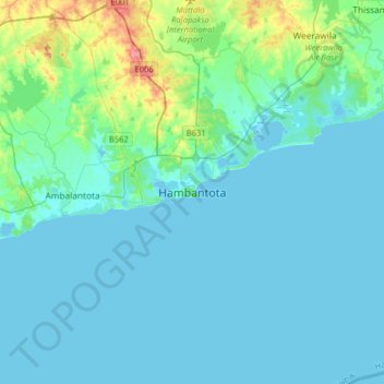
Name: Hambantota topographic map, elevation, terrain.
Location: Hambantota, Hambantota District, Southern Province, Sri Lanka (5.96491 80.96426 6.28491 81.28426)
Average elevation: 39 ft
Minimum elevation: -3 ft
Maximum elevation: 308 ft
Other topographic maps
Click on a map to view its topography, its elevation and its terrain.
DC
Sri Lanka > Southern Province > Hambantota
DC, Hambantota, Hambantota District, Southern Province, 82004, Sri Lanka
Average elevation: 56 ft
DC
Sri Lanka > Southern Province > Hambantota
DC, Hambantota, Hambantota District, Southern Province, Sri Lanka
Average elevation: 79 ft