
Prévost topographic map
Interactive map
Click on the map to display elevation.
About this map
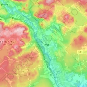
Name: Prévost topographic map, elevation, terrain.
Location: Prévost, La Rivière-du-Nord, Laurentides, Quebec, Canada (45.81812 -74.11230 45.90367 -74.00913)
Average elevation: 787 ft
Minimum elevation: 436 ft
Maximum elevation: 1,224 ft
Other topographic maps
Click on a map to view its topography, its elevation and its terrain.
Saint-Hippolyte
Canada > Quebec > La Rivière-du-Nord
Saint-Hippolyte, La Rivière-du-Nord, Laurentides, Quebec, Canada
Average elevation: 892 ft
Saint-Jérôme
Canada > Quebec > La Rivière-du-Nord
Saint-Jérôme, La Rivière-du-Nord, Laurentides, Quebec, Canada
Average elevation: 456 ft