
Pebbair topographic map
Interactive map
Click on the map to display elevation.
About this map
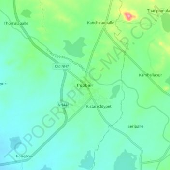
Name: Pebbair topographic map, elevation, terrain.
Location: Pebbair, Pebbair mandal, Wanaparthy, Telangana, 509104, India (16.16528 77.95420 16.24528 78.03420)
Average elevation: 1,014 ft
Minimum elevation: 909 ft
Maximum elevation: 1,375 ft
Pebbair is located at 16°13′00″N 77°59′00″E / 16.2167°N 77.9833°E / 16.2167; 77.9833. It has an average elevation of 300 metres (987 ft).