
Elma topographic map
Interactive map
Click on the map to display elevation.
About this map
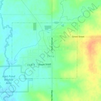
Name: Elma topographic map, elevation, terrain.
Location: Elma, Howard County, Iowa, United States (43.23825 -92.45062 43.25320 -92.42655)
Average elevation: 1,201 ft
Minimum elevation: 1,152 ft
Maximum elevation: 1,286 ft
Other topographic maps
Click on a map to view its topography, its elevation and its terrain.
Riceville
United States > Iowa > Howard County
Riceville, Howard County, Iowa, 50466, United States
Average elevation: 1,234 ft
Protivin
United States > Iowa > Howard County
Protivin, Howard County, Iowa, 52163, United States
Average elevation: 1,178 ft
Cresco
United States > Iowa > Howard County > Cresco
Cresco, Howard County, Iowa, 52136, United States
Average elevation: 1,247 ft