
Fort Stockton topographic map
Interactive map
Click on the map to display elevation.
About this map
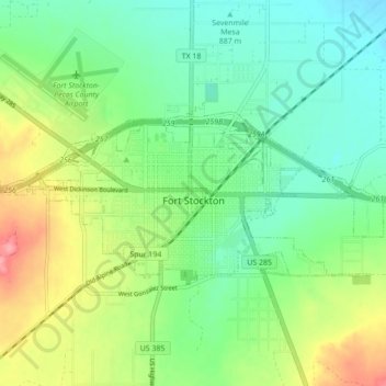
Name: Fort Stockton topographic map, elevation, terrain.
Location: Fort Stockton, Pecos County, Texas, 79735, United States (30.87565 -102.92784 30.91085 -102.84087)
Average elevation: 2,986 ft
Minimum elevation: 2,881 ft
Maximum elevation: 3,189 ft
Other topographic maps
Click on a map to view its topography, its elevation and its terrain.
Belding
United States > Texas > Pecos County
Belding, Pecos County, Texas, United States
Average elevation: 3,215 ft
Bakersfield
United States > Texas > Pecos County
Bakersfield, Pecos County, Texas, United States
Average elevation: 2,552 ft
Girvin
United States > Texas > Pecos County
Girvin, Pecos County, Texas, United States
Average elevation: 2,329 ft
Iraan
United States > Texas > Pecos County
Iraan, Pecos County, Texas, 79744, United States
Average elevation: 2,244 ft
Coyanosa
United States > Texas > Pecos County
Coyanosa, Pecos County, Texas, 79730, United States
Average elevation: 2,612 ft
Imperial
United States > Texas > Pecos County
Imperial, Pecos County, Texas, 79743, United States
Average elevation: 2,395 ft