
Mount Kelud topographic map
Interactive map
Click on the map to display elevation.
About this map
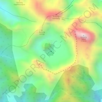
Name: Mount Kelud topographic map, elevation, terrain.
Location: Mount Kelud, Blitar, East Java, Indonesia (-7.93897 112.30520 -7.93887 112.30530)
Average elevation: 4,242 ft
Minimum elevation: 3,235 ft
Maximum elevation: 5,591 ft
Other topographic maps
Click on a map to view its topography, its elevation and its terrain.
Gunung Kidul
Indonesia > East Java > Blitar
Gunung Kidul, Blitar, East Java, Java, Indonesia
Average elevation: 495 ft