
Jakes Landing topographic map
Interactive map
Click on the map to display elevation.
About this map
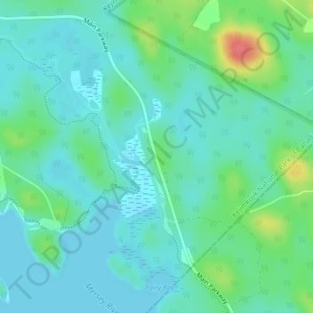
Name: Jakes Landing topographic map, elevation, terrain.
Average elevation: 335 ft
Minimum elevation: 285 ft
Maximum elevation: 495 ft
Other topographic maps
Click on a map to view its topography, its elevation and its terrain.
Kejimkujik National Park and National Historic Site of Canada
Canada > Nova Scotia > Municipality of the County of Annapolis > Kejimkujik National Park of Canada
Kejimkujik National Park and National Historic Site of Canada, Kejimkujik National Park of Canada, Municipality of the County of Annapolis, Annapolis County, Nova Scotia, B0T 1N0, Canada
Average elevation: 397 ft