
Fruitland topographic map
Interactive map
Click on the map to display elevation.
About this map
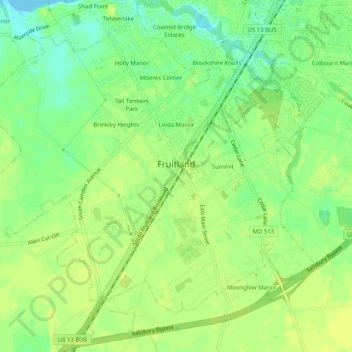
Name: Fruitland topographic map, elevation, terrain.
Location: Fruitland, Wicomico County, Maryland, 21826, United States (38.30239 -75.65086 38.33891 -75.60037)
Average elevation: 36 ft
Minimum elevation: -7 ft
Maximum elevation: 52 ft
Other topographic maps
Click on a map to view its topography, its elevation and its terrain.
Quantico
United States > Maryland > Wicomico County
Quantico, Wicomico County, Maryland, United States
Average elevation: 20 ft
Stellas Venture
United States > Maryland > Wicomico County
Stellas Venture, Wicomico County, Maryland, United States
Average elevation: 62 ft
Walston Switch
United States > Maryland > Wicomico County
Walston Switch, Wicomico County, Maryland, 21849, United States
Average elevation: 59 ft
Salisbury
United States > Maryland > Wicomico County > Salisbury
Salisbury, Wicomico County, Maryland, 21803, United States
Average elevation: 36 ft
Salisbury
United States > Maryland > Wicomico County
Salisbury, Wicomico County, Maryland, United States
Average elevation: 39 ft
Delmar
United States > Maryland > Wicomico County
Delmar, Wicomico County, Maryland, 19940, United States
Average elevation: 49 ft