
Ferdinand topographic map
Interactive map
Click on the map to display elevation.
About this map
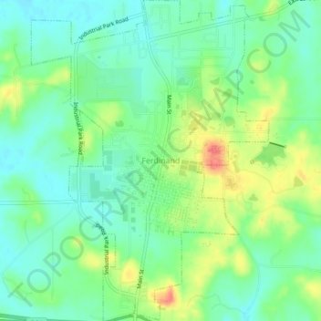
Name: Ferdinand topographic map, elevation, terrain.
Location: Ferdinand, Dubois County, Indiana, 47532, United States (38.20644 -86.88021 38.24140 -86.84721)
Average elevation: 531 ft
Minimum elevation: 466 ft
Maximum elevation: 653 ft
Other topographic maps
Click on a map to view its topography, its elevation and its terrain.
Hillham
United States > Indiana > Dubois County
Hillham, Dubois County, Indiana, United States
Average elevation: 682 ft
Celestine
United States > Indiana > Dubois County
Celestine, Dubois County, Indiana, 47580, United States
Average elevation: 607 ft
Jasper
United States > Indiana > Dubois County > Jasper
Jasper, Dubois County, Indiana, 47546, United States
Average elevation: 492 ft
Holland
United States > Indiana > Dubois County > Holland
Holland, Dubois County, Indiana, United States
Average elevation: 509 ft
Jasper
United States > Indiana > Dubois County > Jasper
Jasper, Dubois County, Indiana, United States
Average elevation: 495 ft
Huntingburg
United States > Indiana > Dubois County
Huntingburg, Dubois County, Indiana, 47542, United States
Average elevation: 486 ft