
Rising Fawn topographic map
Interactive map
Click on the map to display elevation.
About this map
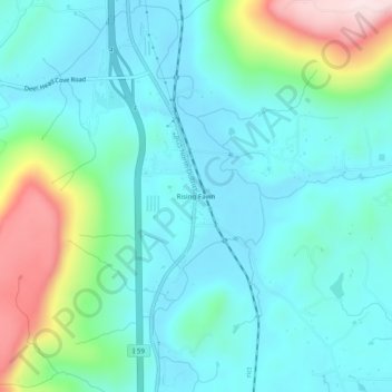
Name: Rising Fawn topographic map, elevation, terrain.
Location: Rising Fawn, Dade County, Georgia, United States (34.74008 -85.55108 34.78008 -85.51108)
Average elevation: 1,030 ft
Minimum elevation: 738 ft
Maximum elevation: 2,057 ft
Other topographic maps
Click on a map to view its topography, its elevation and its terrain.
Trenton
United States > Georgia > Dade County
Trenton, Dade County, Georgia, United States
Average elevation: 919 ft
West Brow
United States > Georgia > Dade County
West Brow, Dade County, Georgia, 30757, United States
Average elevation: 1,398 ft
Head River
United States > Georgia > Dade County
Head River, Dade County, Georgia, United States
Average elevation: 1,919 ft
Cole City
United States > Georgia > Dade County
Cole City, Dade County, Georgia, United States
Average elevation: 1,414 ft
Wildwood
United States > Georgia > Dade County
Wildwood, Dade County, Georgia, 30757, United States
Average elevation: 846 ft
New England
United States > Georgia > Dade County
New England, Dade County, Georgia, United States
Average elevation: 794 ft
New England
United States > Georgia > Dade County
New England, Dade County, Georgia, 30752, United States
Average elevation: 843 ft
Trenton
United States > Georgia > Dade County
Trenton, Dade County, Georgia, United States
Average elevation: 919 ft
Cole City
United States > Georgia > Dade County
Cole City, Dade County, Georgia, United States
Average elevation: 1,368 ft