
Decorah topographic map
Interactive map
Click on the map to display elevation.
About this map
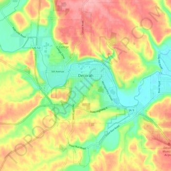
Name: Decorah topographic map, elevation, terrain.
Location: Decorah, Winneshiek County, Iowa, United States (43.26857 -91.81755 43.33126 -91.71868)
Average elevation: 1,014 ft
Minimum elevation: 823 ft
Maximum elevation: 1,217 ft
Other topographic maps
Click on a map to view its topography, its elevation and its terrain.
Ossian
United States > Iowa > Winneshiek County
Ossian, Winneshiek County, Iowa, United States
Average elevation: 1,230 ft
Freeport
United States > Iowa > Winneshiek County
Freeport, Winneshiek County, Iowa, 52101, United States
Average elevation: 981 ft
Ridgeway
United States > Iowa > Winneshiek County
Ridgeway, Winneshiek County, Iowa, United States
Average elevation: 1,194 ft
Calmar
United States > Iowa > Winneshiek County
Calmar, Winneshiek County, Iowa, United States
Average elevation: 1,234 ft
Fort Atkinson
United States > Iowa > Winneshiek County
Fort Atkinson, Winneshiek County, Iowa, United States
Average elevation: 1,053 ft