
Lake Sakakawea topographic map
Interactive map
Click on the map to display elevation.
About this map
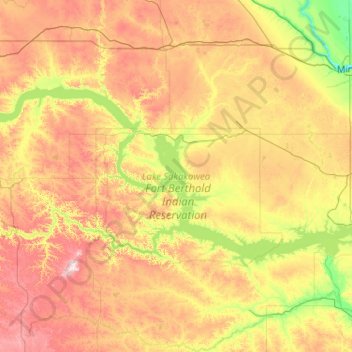
Name: Lake Sakakawea topographic map, elevation, terrain.
Location: Lake Sakakawea, McLean County, North Dakota, USA (47.45250 -103.31128 48.17134 -101.24982)
Average elevation: 2,136 ft
Minimum elevation: 1,555 ft
Maximum elevation: 3,274 ft
Other topographic maps
Click on a map to view its topography, its elevation and its terrain.
Theodore Roosevelt National Park
Theodore Roosevelt National Park, Billings County, North Dakota, USA
Average elevation: 2,244 ft
Lake Ashtabula
Lake Ashtabula, 15th Street Southeast, Barnes County, North Dakota, 58056, USA
Average elevation: 1,388 ft
Lake Tschida
Lake Tschida, 56th Street Southwest, Grant County, North Dakota, USA
Average elevation: 2,169 ft
Rock Lake
USA > North Dakota > Rock Lake
Rock Lake, Towner County, North Dakota, USA
Average elevation: 1,549 ft
Sheyenne River
Sheyenne River, Nelson County, North Dakota, 58361, USA
Average elevation: 1,404 ft
General Sibley Park & Campground
General Sibley Park & Campground, Burleigh County, North Dakota, USA
Average elevation: 1,634 ft
Forest River
Forest River, Walsh County, North Dakota, USA
Average elevation: 804 ft
Lake Metigoshe State Park
Lake Metigoshe State Park, Bottineau County, North Dakota, USA
Average elevation: 2,165 ft
Boundary Lake
Boundary Lake, 23rd Avenue Northeast, Bottineau County, North Dakota, USA
Average elevation: 2,247 ft
Dunseith
USA > North Dakota > Dunseith
Dunseith, Rolette County, North Dakota, USA
Average elevation: 1,709 ft