
Savaiʻi topographic map
Interactive map
Click on the map to display elevation.
About this map
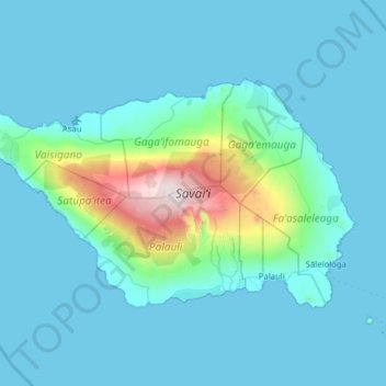
Name: Savaiʻi topographic map, elevation, terrain.
Location: Savaiʻi, Samoa (-13.80370 -172.80407 -13.43881 -172.17404)
Average elevation: 561 ft
Minimum elevation: 0 ft
Maximum elevation: 6,027 ft
The tropical climate and fertile soil results in a variety of flora. Vegetation types include littoral, wetland and volcanic vegetation. Rainforests include coastal, lowland and montane forests (above 500m elevation). Cloud forests are located in the highest elevations of the island which are often under cloud cover with wet conditions. At Mt Silisili, cloud forest occur above 1200m elevation. The Savaiʻi forest is dominated by a 15 to 20 m high canopy of Dysoxylum huntii, Omalanthus acuminatus, Reynoldsia pleiosperma and Weinmannia samoense. Other common trees include Coprosma savaiiense, Psychotria xanthochlora, Spiraeanthemum samoense and Streblus anthropophagorum. There are nearly 500 species of flowering plants and about 200 species of ferns in Samoa, making it richer than that of any tropical Polynesian island other than those in the Hawaiian archipelago. About 25% of the species are endemic to Samoa.
Other topographic maps
Click on a map to view its topography, its elevation and its terrain.
Sālelologa
Samoa > Faʻasaleleaga > Sālelologa
Sālelologa, Faʻasaleleaga, Samoa
Average elevation: 144 ft