
الصخیرة topographic map
Interactive map
Click on the map to display elevation.
About this map
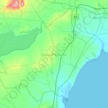
Name: الصخیرة topographic map, elevation, terrain.
Location: الصخیرة, Sfax, Tunisia (34.16800 9.71110 34.52583 10.19764)
Average elevation: 164 ft
Minimum elevation: -10 ft
Maximum elevation: 1,322 ft
Other topographic maps
Click on a map to view its topography, its elevation and its terrain.
سكرة
Tunisia > Sfax > معتمدية صفاقس الغربية
سكرة, معتمدية صفاقس الغربية, Sfax, 3003, Tunisia
Average elevation: 20 ft