
Campbell Island / Motu Ihupuku topographic map
Interactive map
Click on the map to display elevation.
About this map
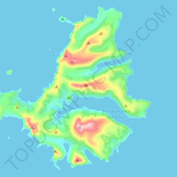
Name: Campbell Island / Motu Ihupuku topographic map, elevation, terrain.
Location: Campbell Island / Motu Ihupuku, New Zealand (-52.60883 169.01495 -52.46608 169.26839)
Average elevation: 171 ft
Minimum elevation: -13 ft
Maximum elevation: 1,804 ft
The whaling boom extended here in the 1830s and '40s. In 1874, the island was visited by a French scientific expedition intending to view the transit of Venus. Much of the island's topography is named after aspects of, or people connected with, the expedition.
Other topographic maps
Click on a map to view its topography, its elevation and its terrain.
Dragons Teeth
New Zealand > Tasman > Tasman District
Dragons Teeth, Tasman District, Tasman, New Zealand
Average elevation: 3,983 ft
Sutherland Falls
New Zealand > Southland > Southland District > Fiordland Community
Sutherland Falls, Fiordland Community, Southland District, Southland, New Zealand
Average elevation: 3,301 ft
Mount Blanc
Mount Blanc, Marlborough, New Zealand
Average elevation: 2,700 ft
Ohinepaka Bay
New Zealand > Canterbury > Christchurch City > Banks Peninsula Community > Wainui
Ohinepaka Bay, Wainui, Banks Peninsula Community, Christchurch City, Canterbury, 7582, New Zealand
Average elevation: 308 ft
Great Barrier Island
Great Barrier Island, Auckland, 0991, New Zealand
Average elevation: 102 ft
Pitt Island (Rangiauria)
Pitt Island (Rangiauria), Chatham Islands, New Zealand
Average elevation: 33 ft
Rakiura Rocks
New Zealand > Marlborough > Marlborough District
Rakiura Rocks, Marlborough District, Marlborough, New Zealand
Average elevation: 33 ft
Pōkeno
New Zealand > Waikato > Waikato District
Pōkeno, Waikato District, Waikato, 2472, New Zealand
Average elevation: 217 ft
Woodend Beach
New Zealand > Canterbury > Waimakariri District
Woodend Beach, Waimakariri District, Canterbury, 7612, New Zealand
Average elevation: 10 ft
Cascade Kauri Picture Frame
New Zealand > Auckland > Waitakere Ranges
Cascade Kauri Picture Frame, Falls Road, Waitākere Ranges, Auckland, 0816, New Zealand
Average elevation: 463 ft
Pyramids
New Zealand > Otago > Dunedin City
Pyramids, Dunedin City, Otago, New Zealand
Average elevation: 171 ft
Gisborne
New Zealand > Gisborne > Gisborne District
Gisborne, Gisborne District, Gisborne, 4010, New Zealand
Average elevation: 230 ft
Mount Livingstone
New Zealand > Canterbury > Mackenzie District
Mount Livingstone, Mackenzie District, Canterbury, New Zealand
Average elevation: 6,381 ft
Selwyn District
Selwyn District, Canterbury, New Zealand
Average elevation: 2,228 ft
Punakaiki
New Zealand > West Coast > Buller District
Punakaiki, Buller District, West Coast, 7873, New Zealand
Average elevation: 230 ft
Days Bay
New Zealand > Wellington > Lower Hutt
Days Bay, Lower Hutt, Wellington, 5013, New Zealand
Average elevation: 243 ft
Upper Hutt
New Zealand > Wellington > Upper Hutt City
Upper Hutt, Upper Hutt City, Wellington, 5218, New Zealand
Average elevation: 889 ft
Snow Bowl
New Zealand > Taranaki > Stratford District
Snow Bowl, Stratford District, Taranaki, New Zealand
Average elevation: 4,813 ft
Central Otago
New Zealand > Otago > Central Otago District > Vincent Community
Central Otago, Vincent Community, Central Otago District, Otago, 9035, New Zealand
Average elevation: 3,068 ft
Hahei Beach
New Zealand > Waikato > Thames-Coromandel District > Hahei
Hahei Beach, Hahei, Thames-Coromandel District, Waikato, New Zealand
Average elevation: 95 ft
Tikorangi
New Zealand > Bay of Plenty > Whakatāne District
Tikorangi, Whakatāne District, Bay of Plenty, New Zealand
Average elevation: 1,588 ft
Lake Panorama
New Zealand > Auckland > Henderson-Massey
Lake Panorama, Western Heights, Henderson-Massey, Auckland, New Zealand
Average elevation: 171 ft
Mana Island
New Zealand > Wellington > Porirua City > Porirua
Mana Island, Porirua, Porirua City, Wellington, New Zealand
Average elevation: 52 ft
Putāruru
New Zealand > Waikato > South Waikato District
Putāruru, South Waikato District, Waikato, 3411, New Zealand
Average elevation: 545 ft
Kaimai Range
New Zealand > Bay of Plenty > Western Bay of Plenty District
Kaimai Range, Western Bay of Plenty District, Bay of Plenty, New Zealand
Average elevation: 1,952 ft
Waiari Reserve
New Zealand > Auckland > Papakura
Waiari Reserve, Conifer Grove, Papakura, Auckland, New Zealand
Average elevation: 39 ft
Ōakura
New Zealand > Taranaki > New Plymouth District
Ōakura, New Plymouth District, Taranaki, 4314, New Zealand
Average elevation: 243 ft
Shalamar Reserve
New Zealand > Canterbury > Christchurch City > Christchurch
Shalamar Reserve, Cashmere, Christchurch, Christchurch City, Canterbury, New Zealand
Average elevation: 157 ft
Remus
New Zealand > Canterbury > Selwyn District
Remus, Selwyn District, Canterbury, New Zealand
Average elevation: 2,034 ft
Whitianga
New Zealand > Bay of Plenty > Ōpōtiki District
Whitianga, Ōpōtiki District, Bay of Plenty, 3162, New Zealand
Average elevation: 138 ft
Cape Kidnappers / Te Kauwae-a-Māui
New Zealand > Hawke's Bay > Hastings District
Cape Kidnappers / Te Kauwae-a-Māui, Hastings District, Hawke's Bay, New Zealand
Average elevation: 52 ft
Wilson's Beach
New Zealand > Auckland > Ōrākei
Wilson's Beach, Ōrākei, Auckland, New Zealand
Average elevation: 69 ft
Douglas Pass
New Zealand > West Coast > Westland District
Douglas Pass, Westland District, West Coast, New Zealand
Average elevation: 5,259 ft
Little River
Little River, Canterbury, New Zealand, Whale Island
Average elevation: 30 ft
Waikato District
Waikato District, Waikato, New Zealand
Average elevation: 220 ft
Coastal-Burwood Community
New Zealand > Canterbury > Christchurch City
Coastal-Burwood Community, Christchurch City, Canterbury, New Zealand
Average elevation: 20 ft
Bridal Veil Falls
New Zealand > Waikato > Rotorua Lakes District
Bridal Veil Falls, Rotorua Lakes District, Waikato, New Zealand
Average elevation: 1,158 ft
Lake Windermere
New Zealand > West Coast > Westland District
Lake Windermere, Westland District, West Coast, New Zealand
Average elevation: 13 ft
Round Knob
New Zealand > Manawatu-Whanganui > Tararua District
Round Knob, Tararua District, Manawatū-Whanganui, New Zealand
Average elevation: 784 ft
Zig Zag
New Zealand > Canterbury > Christchurch City > Banks Peninsula Community
Zig Zag, Banks Peninsula Community, Christchurch City, Canterbury, New Zealand
Average elevation: 446 ft