
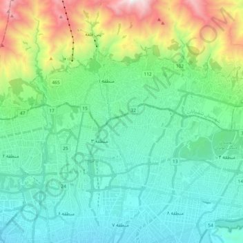
Shemiranat County topographic map
Interactive map
Click on the map to display elevation.
About this map
Name: Shemiranat County topographic map, elevation, terrain.
Location: Tajrish City, بخش رودبار قصران, Shemiranat County, Iran (35.73671 51.35454 35.82847 51.53817)
Average elevation: 5,568 ft
Minimum elevation: 3,963 ft
Maximum elevation: 10,873 ft
Other topographic maps
Click on a map to view its topography, its elevation and its terrain.
District 2
Iran > Tehran Province > Tajrish City
Shahrak Gharb, District 2, Tajrish City, بخش رودبار قصران, Shemiranat County, Tehran Province, 14658, Iran
Average elevation: 4,780 ft