
Lagan topographic map
Interactive map
Click on the map to display elevation.
About this map
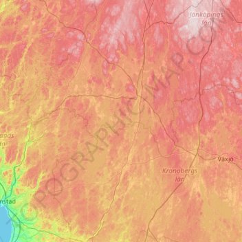
Name: Lagan topographic map, elevation, terrain.
Average elevation: 568 ft
Minimum elevation: 0 ft
Maximum elevation: 1,211 ft
Other topographic maps
Click on a map to view its topography, its elevation and its terrain.
Möckeln
Sweden > Kronoberg County > Pjätteryd
Möckeln, G 598, Pjätteryd, Älmhult, Kronoberg County, Region Götaland, 34393, Sweden
Average elevation: 466 ft
Fläskes
Sweden > Kronoberg County > Diö
Fläskes, Åspromenden, Duvelycke, Diö, Älmhult, Kronoberg County, Region Götaland, 34371, Sweden
Average elevation: 453 ft
Harö
Harö, G 682, Tingsryd, Kronoberg County, Region Götaland, Sweden
Average elevation: 449 ft
Agunnaryd
Sweden > Kronoberg County > Agunnaryd
Agunnaryd, Ljungby kommun, Kronoberg County, Region Götaland, 34177, Sweden
Average elevation: 466 ft
Tingsryd
Sweden > Kronoberg County > Tingsryd
Tingsryd, Kronoberg County, Region Götaland, 36221, Sweden
Average elevation: 479 ft
Älmhult
Sweden > Kronoberg County > Älmhult
Älmhult, Kronoberg County, Region Götaland, 343 21, Sweden
Average elevation: 492 ft