
Picos de Europa topographic map
Interactive map
Click on the map to display elevation.
About this map
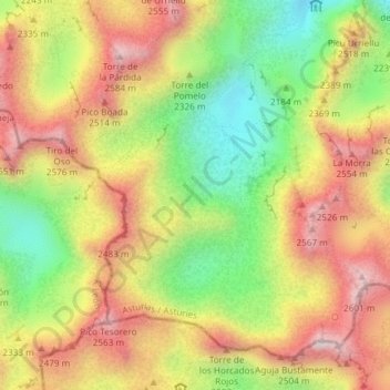
Name: Picos de Europa topographic map, elevation, terrain.
Location: Picos de Europa, Cabrales, Asturië, 33554, Spanje (43.17960 -4.84275 43.19960 -4.82275)
Average elevation: 7,513 ft
Minimum elevation: 6,407 ft
Maximum elevation: 8,550 ft
De rotsen zijn bijna allemaal van kalksteen en glaciale krachten hebben bijgedragen aan een opmerkelijk gebied van alpine karstverschijnselen. Vele bergtoppen komen boven de 2400 meter uit. De hoogste bergtop is, met een hoogte van 2648 meter de Torre de Cerredo. Het gebied is populair bij bergbeklimmers en -wandelaars. Er is een netwerk van goed onderhouden bergschuilplaatsen. De bekendste plek om te klimmen is de Naranjo de Bulnes.
Other topographic maps
Click on a map to view its topography, its elevation and its terrain.
Majada de Ostón
Majada de Ostón, Cabrales, Asturië, 33555, Spanje
Average elevation: 3,625 ft
Bulnes de Arriba (El Castillo)
Bulnes de Arriba (El Castillo), Cabrales, Asturië, 33554, Spanje
Average elevation: 3,734 ft