
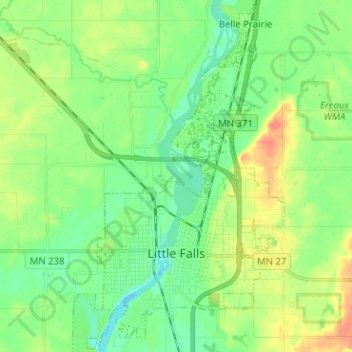
Little Falls topographic map
Interactive map
Click on the map to display elevation.
About this map
Name: Little Falls topographic map, elevation, terrain.
Average elevation: 1,142 ft
Minimum elevation: 1,083 ft
Maximum elevation: 1,243 ft
Other topographic maps
Click on a map to view its topography, its elevation and its terrain.
Pierz
United States > Minnesota > Morrison County
Pierz, Morrison County, Minnesota, United States
Average elevation: 1,168 ft
Royalton
United States > Minnesota > Morrison County
Royalton, Morrison County, Minnesota, United States
Average elevation: 1,089 ft
Little Falls
United States > Minnesota > Morrison County > Little Falls
Little Falls, Morrison County, Minnesota, 56345, United States
Average elevation: 1,138 ft
Hillman
United States > Minnesota > Morrison County
Hillman, Morrison County, Minnesota, 56338, United States
Average elevation: 1,312 ft
Motley
United States > Minnesota > Morrison County
Motley, Morrison County, Minnesota, United States
Average elevation: 1,230 ft