
Zembra topographic map
Interactive map
Click on the map to display elevation.
About this map
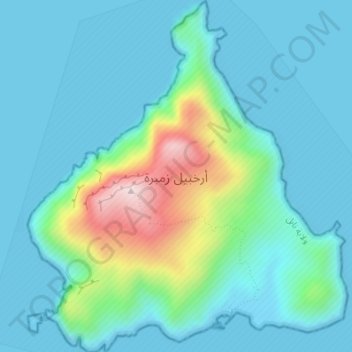
Name: Zembra topographic map, elevation, terrain.
Location: Zembra, Nabeul, Tunisia (37.11594 10.78893 37.14315 10.82000)
Average elevation: 243 ft
Minimum elevation: -3 ft
Maximum elevation: 1,325 ft
Other topographic maps
Click on a map to view its topography, its elevation and its terrain.
Kelibia
Tunisia > Nabeul > قليبية الغربية
Kelibia, قليبية الغربية, معتمدية قليبية, Nabeul, Tunisia
Average elevation: 56 ft
قليبية الغربية
قليبية الغربية, معتمدية قليبية, Nabeul, 8090, Tunisia
Average elevation: 49 ft
Menzel Temime
Tunisia > Nabeul > علي بلهوان
Menzel Temime, علي بلهوان, معتمدية منزل تميم, Nabeul, 8080, Tunisia
Average elevation: 62 ft
Kelibia
Tunisia > Nabeul > قليبية الغربية
Kelibia, قليبية الغربية, معتمدية قليبية, Nabeul, 8090, Tunisia
Average elevation: 59 ft