
Ashland topographic map
Interactive map
Click on the map to display elevation.
About this map
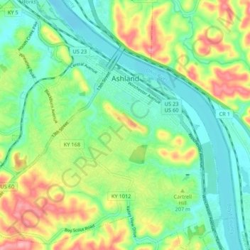
Name: Ashland topographic map, elevation, terrain.
Location: Ashland, Boyd County, Kentucky, 41101, United States (38.43440 -82.68193 38.49846 -82.60629)
Average elevation: 643 ft
Minimum elevation: 509 ft
Maximum elevation: 886 ft
Other topographic maps
Click on a map to view its topography, its elevation and its terrain.
Ironville
United States > Kentucky > Boyd County
Ironville, Boyd County, Kentucky, 41102, United States
Average elevation: 702 ft
Westwood
United States > Kentucky > Boyd County > Fairview
Westwood, Fairview, Boyd County, Kentucky, United States
Average elevation: 630 ft
Cannonsburg
United States > Kentucky > Boyd County
Cannonsburg, Boyd County, Kentucky, 41105, United States
Average elevation: 712 ft
Boltsfork
United States > Kentucky > Boyd County > Boltsfork
Boltsfork, Boyd County, Kentucky, United States
Average elevation: 791 ft
Catlettsburg
United States > Kentucky > Boyd County
Catlettsburg, Boyd County, Kentucky, United States
Average elevation: 623 ft
Rush
United States > Kentucky > Boyd County
Rush, Boyd County, Kentucky, 41168, United States
Average elevation: 801 ft