
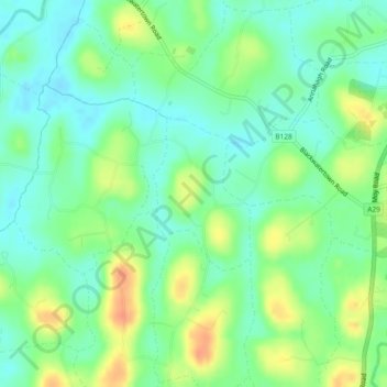
Creaghan topographic map
Interactive map
Click on the map to display elevation.
About this map
Name: Creaghan topographic map, elevation, terrain.
Average elevation: 92 ft
Minimum elevation: 39 ft
Maximum elevation: 177 ft
Other topographic maps
Click on a map to view its topography, its elevation and its terrain.
Derryfubble
United Kingdom > Northern Ireland > Armagh
Derryfubble, Armagh, Northern Ireland, United Kingdom
Average elevation: 207 ft
Drumay
United Kingdom > Northern Ireland > Armagh
Drumay, Armagh, Northern Ireland, United Kingdom
Average elevation: 190 ft
Tullysaran
United Kingdom > Northern Ireland > Armagh
Tullysaran, Armagh, Northern Ireland, United Kingdom
Average elevation: 118 ft
Ballymartrim Etra
United Kingdom > Northern Ireland > Armagh
Ballymartrim Etra, Armagh, Northern Ireland, United Kingdom
Average elevation: 105 ft
Blackwater
United Kingdom > Northern Ireland > Armagh
Blackwater, Armagh, County Armagh, Northern Ireland, United Kingdom
Average elevation: 144 ft
Killylea
United Kingdom > Northern Ireland > Armagh
Killylea, Armagh, County Armagh, Northern Ireland, BT60 4LN, United Kingdom
Average elevation: 246 ft
Mullenakill West
United Kingdom > Northern Ireland > Armagh
Mullenakill West, Armagh, County Armagh, Northern Ireland, United Kingdom
Average elevation: 56 ft