
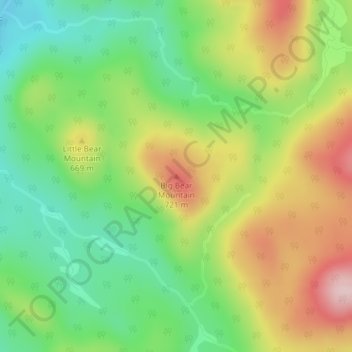
Big Bear Mountain topographic map
Interactive map
Click on the map to display elevation.
About this map
Name: Big Bear Mountain topographic map, elevation, terrain.
Average elevation: 2,021 ft
Minimum elevation: 1,673 ft
Maximum elevation: 2,493 ft
Other topographic maps
Click on a map to view its topography, its elevation and its terrain.
Gore Mountain
United States > New York > Warren County > Town of Johnsburg
Gore Mountain, Town of Johnsburg, Warren County, New York, United States
Average elevation: 2,762 ft
North Creek
United States > New York > Warren County > Town of Johnsburg
North Creek, Town of Johnsburg, Warren County, New York, United States
Average elevation: 1,227 ft
Garnet Lake
United States > New York > Warren County > Town of Johnsburg
Garnet Lake, Town of Johnsburg, Town of Thurman, Warren County, New York, United States
Average elevation: 1,759 ft
Thirteenth Lake
United States > New York > Warren County > Town of Johnsburg
Thirteenth Lake, Town of Johnsburg, Warren County, New York, United States
Average elevation: 1,962 ft
Windover Lake
United States > New York > Warren County > Town of Johnsburg
Windover Lake, Town of Johnsburg, Warren County, New York, United States
Average elevation: 1,634 ft
Austin Pond
United States > New York > Warren County > Town of Johnsburg
Austin Pond, Town of Johnsburg, Warren County, New York, United States
Average elevation: 1,325 ft
Crane Mountain
United States > New York > Warren County > Town of Johnsburg
Crane Mountain, Town of Johnsburg, Warren County, New York, United States
Average elevation: 2,274 ft