
Latakia topographic map
Interactive map
Click on the map to display elevation.
About this map
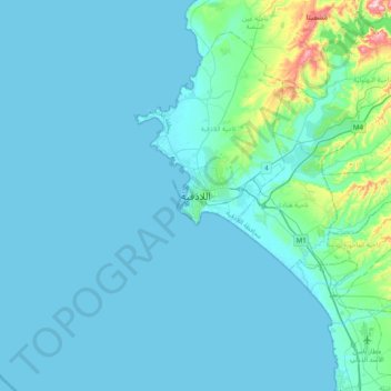
Name: Latakia topographic map, elevation, terrain.
Average elevation: 92 ft
Minimum elevation: -3 ft
Maximum elevation: 1,066 ft
Other topographic maps
Click on a map to view its topography, its elevation and its terrain.
Al Qasab
Al Qasab, Rabia Subdistrict, Latakia District, Latakia Governorate, Syria
Average elevation: 928 ft
Ra's Shamrah
Syria > Latakia Governorate > Burj al Qasab
Ra's Shamrah, Burj al Qasab, Latakia Subdistrict, Latakia District, Latakia Governorate, Syria
Average elevation: 46 ft
Al Bibar
Syria > Latakia Governorate > Marj az Zawiyah > Al Bibar
Al Bibar, Marj az Zawiyah, Kinsabba Subdistrict, Al-Haffa District, Latakia Governorate, Syria
Average elevation: 1,188 ft