
Glen Arbor topographic map
Interactive map
Click on the map to display elevation.
About this map
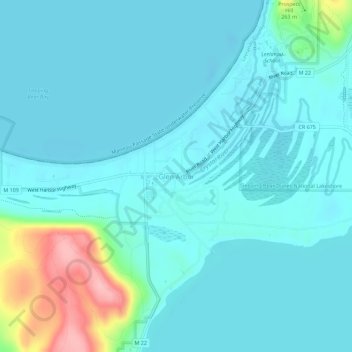
Name: Glen Arbor topographic map, elevation, terrain.
Average elevation: 636 ft
Minimum elevation: 564 ft
Maximum elevation: 1,020 ft
Other topographic maps
Click on a map to view its topography, its elevation and its terrain.
Suttons Bay
United States > Michigan > Leelanau County
Suttons Bay, Suttons Bay Township, Leelanau County, Michigan, United States
Average elevation: 676 ft
Northport
United States > Michigan > Leelanau County
Northport, Leelanau Township, Leelanau County, Michigan, 49670, United States
Average elevation: 633 ft
Cedar
United States > Michigan > Leelanau County
Cedar, Solon Township, Leelanau County, Michigan, 49621, United States
Average elevation: 643 ft
Leland
United States > Michigan > Leelanau County
Leland, Leland Township, Leelanau County, Michigan, 49654, United States
Average elevation: 594 ft
Empire Township
United States > Michigan > Leelanau County
Empire Township, Leelanau County, Michigan, United States
Average elevation: 801 ft
North Manitou Island
United States > Michigan > Leelanau County
North Manitou Island, Leland Township, Leelanau County, Michigan, United States
Average elevation: 640 ft
Maple City
United States > Michigan > Leelanau County > Maple City
Maple City, Kasson Township, Leelanau County, Michigan, 49664, United States
Average elevation: 804 ft
Empire
United States > Michigan > Leelanau County
Empire, Empire Township, Leelanau County, Michigan, United States
Average elevation: 673 ft
Sleeping Bear Dunes
United States > Michigan > Leelanau County
Sleeping Bear Dunes, Glen Arbor Township, Leelanau County, Michigan, United States
Average elevation: 758 ft