
Goodenough Island topographic map
Interactive map
Click on the map to display elevation.
About this map
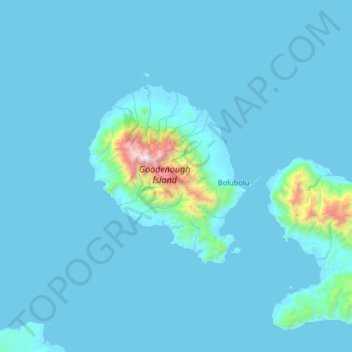
Name: Goodenough Island topographic map, elevation, terrain.
Location: Goodenough Island, Milne Bay, Papua Region, Papua New Guinea (-9.68125 149.93705 -9.04125 150.57705)
Average elevation: 338 ft
Minimum elevation: -3 ft
Maximum elevation: 8,136 ft
Like much of New Guinea, the climate is tropical with high temperatures and humidity throughout the year. The northwest monsoon season lasts from December to March and brings sudden rain squalls. From May to October southeasterly winds are cooler and more gentle. Tropical cyclones are infrequent. Rainfall varies between 1,520 mm and 2,540 mm per annum. Serious droughts occur once or twice a decade. Rushing streams with waterfalls drain water from the central mountain. Rain forest cloaks the higher elevations with secondary forest, grassland and native gardens on the lower slopes and coastal plains. Soils are acidic.
Other topographic maps
Click on a map to view its topography, its elevation and its terrain.
Sunday Island
Sunday Island, Milne Bay, Southern Region, Papua New Guinea
Average elevation: 390 ft
Alotau
Papua New Guinea > Milne Bay > Milne Bay District > Alotau
Alotau, Milne Bay District, Milne Bay, Southern Region, Papua New Guinea
Average elevation: 404 ft
Tagula Island
Tagula Island, Milne Bay, Southern Region, Papua New Guinea
Average elevation: 59 ft
D'Entrecasteaux Islands
D'Entrecasteaux Islands, Milne Bay, Southern Region, Papua New Guinea
Average elevation: 249 ft
Fergusson Island
Fergusson Island, Esa’ala District, Milne Bay, Papua Region, Papua New Guinea
Average elevation: 322 ft
Normanby Island
Normanby Island, Esa’ala District, Milne Bay, Papua Region, Papua New Guinea
Average elevation: 161 ft
D’Entrecasteaux Islands
D’Entrecasteaux Islands, Esa’ala District, Milne Bay, Papua Region, Papua New Guinea
Average elevation: 335 ft
Woodlark Island
Woodlark Island, Milne Bay, Papua Region, Papua New Guinea
Average elevation: 30 ft
Sideia Island
Sideia Island, Milne Bay District, Milne Bay, Papua Region, Papua New Guinea
Average elevation: 98 ft