
Mount Adams topographic map
Interactive map
Click on the map to display elevation.
About this map
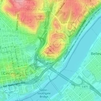
Name: Mount Adams topographic map, elevation, terrain.
Location: Mount Adams, Cincinnati, Hamilton County, Ohio, 45202, USA (39.10750 -84.49916 39.10760 -84.49906)
Average elevation: 594 ft
Minimum elevation: 446 ft
Maximum elevation: 889 ft
Other topographic maps
Click on a map to view its topography, its elevation and its terrain.
Ohio River
USA > Ohio > Cincinnati
Ohio River, East Pete Rose Way, Lytle Park Historic District, Mount Adams, Cincinnati, Hamilton County, Ohio, 45202, USA
Average elevation: 581 ft
Clifton
USA > Ohio > Cincinnati
Clifton, Cincinnati, Hamilton County, Ohio, USA
Average elevation: 636 ft
The Heights
USA > Ohio > Cincinnati
The Heights, Cincinnati, Hamilton County, Ohio, USA
Average elevation: 722 ft
Corryville
USA > Ohio > Cincinnati
Corryville, Cincinnati, Hamilton County, Ohio, USA
Average elevation: 778 ft
Filson Park
USA > Ohio > Cincinnati
Filson Park, Prospect Hill Historic District, Prospect Hill, Cincinnati, Hamilton County, Ohio, USA
Average elevation: 676 ft