
Waiheke Island topographic map
Interactive map
Click on the map to display elevation.
About this map
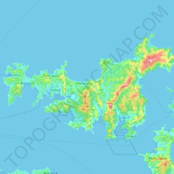
Name: Waiheke Island topographic map, elevation, terrain.
Location: Waiheke Island, Waiheke, Auckland, New Zealand (-36.84838 174.98131 -36.73786 175.20298)
Average elevation: 52 ft
Minimum elevation: -3 ft
Maximum elevation: 728 ft
Other topographic maps
Click on a map to view its topography, its elevation and its terrain.
Browns Island (Motukorea)
New Zealand > Auckland > Waiheke
Browns Island (Motukorea), Waiheke, Auckland, New Zealand
Average elevation: 3 ft
Rangitoto Island
New Zealand > Auckland > Waiheke
Rangitoto Island, Waiheke, Waitematā and Gulf Ward, Auckland, New Zealand
Average elevation: 98 ft