
Patcham topographic map
Interactive map
Click on the map to display elevation.
About this map
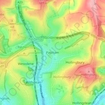
Name: Patcham topographic map, elevation, terrain.
Location: Patcham, Brighton and Hove, England, BN1 8QF, United Kingdom (50.84348 -0.16589 50.88348 -0.12589)
Average elevation: 322 ft
Minimum elevation: 95 ft
Maximum elevation: 620 ft
Other topographic maps
Click on a map to view its topography, its elevation and its terrain.
Brighton
United Kingdom > England > Brighton and Hove
Brighton, Brighton and Hove, England, United Kingdom
Average elevation: 210 ft
Carlton Hill
United Kingdom > England > Brighton and Hove > Brighton
Carlton Hill, Queen's Park, Brighton, Brighton and Hove, England, BN2 9HS, United Kingdom
Average elevation: 112 ft
Hove
United Kingdom > England > Brighton and Hove
Hove, Brighton and Hove, England, BN3 2AD, United Kingdom
Average elevation: 115 ft
Portslade by Sea
United Kingdom > England > Brighton and Hove
Portslade by Sea, Brighton and Hove, England, BN41 1GB, United Kingdom
Average elevation: 115 ft
Rottingdean
United Kingdom > England > Brighton and Hove
Rottingdean, Brighton and Hove, England, United Kingdom
Average elevation: 184 ft
Ovingdean
United Kingdom > England > Brighton and Hove
Ovingdean, Brighton and Hove, England, BN2 7BB, United Kingdom
Average elevation: 190 ft
Stanmer Park
United Kingdom > England > Brighton and Hove > Stanmer
Stanmer Park, Coldean, Stanmer, Brighton and Hove, England, BN1 9QA, United Kingdom
Average elevation: 328 ft
Stanmer
United Kingdom > England > Brighton and Hove
Stanmer, Brighton and Hove, England, BN1 9PZ, United Kingdom
Average elevation: 390 ft