
Porto Santo topographic map
Interactive map
Click on the map to display elevation.
About this map
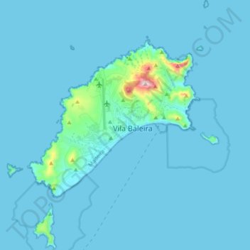
Name: Porto Santo topographic map, elevation, terrain.
Location: Porto Santo, Madeira, Portugal (32.99612 -16.41074 33.12816 -16.27738)
Average elevation: 72 ft
Minimum elevation: -7 ft
Maximum elevation: 1,588 ft
Other topographic maps
Click on a map to view its topography, its elevation and its terrain.
São Martinho
Portugal > Madeira > São Martinho
São Martinho, Funchal, Madeira, Portugal
Average elevation: 433 ft