
Baffin Island topographic map
Interactive map
Click on the map to display elevation.
About this map
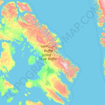
Name: Baffin Island topographic map, elevation, terrain.
Location: Baffin Island, Canada (61.86201 -90.11200 73.86118 -61.26000)
Average elevation: 433 ft
Minimum elevation: -7 ft
Maximum elevation: 6,568 ft
The Baffin Mountains run along the northeastern coast of the island and are a part of the Arctic Cordillera. The highest peak is Mount Odin, with an elevation of at least 2,143 m (7,031 ft), although some sources say 2,147 m (7,044 ft). Another peak of note is Mount Asgard, located in Auyuittuq National Park, with an elevation of 2,011 m (6,598 ft). Mount Thor, with an elevation of 1,675 m (5,495 ft), is said to have the greatest purely vertical drop (a sheer cliff face) of any mountain on Earth, at 1,250 m (4,100 ft). Mount Sharat, with an elevation of 422 m (1,385 ft) and a prominence of 67 m (220 ft) is located on Baffin Island. The mountain is named after geologist Sharat Kumar Roy, the chief geology curator in the Field Museum of Natural History, Chicago. Roy, a native of India, studied in India, London, and earned his Ph.D. at the University of Chicago. Shortly after he started at the Field Museum he joined the 1927-1928 Rawson-Macmillan Expedition to Baffin Island and Labrador. This 15-month expedition began in June 1927.
Other topographic maps
Click on a map to view its topography, its elevation and its terrain.
Quebec
Canada > Quebec > Urban agglomeration of Québec
Quebec, Urban agglomeration of Québec, Capitale-Nationale, Quebec, Canada
Average elevation: 384 ft
Flat Rock
Canada > Nova Scotia > Municipality of the County of Richmond > Grand River
Flat Rock, Grand River, Municipality of the County of Richmond, Richmond County, Nova Scotia, Canada
Average elevation: 16 ft
King Edward Park
Canada > Alberta > Division No. 11 > Edmonton
King Edward Park, Mill Creek South, Edmonton, Division No. 11, Alberta, Canada
Average elevation: 2,201 ft
Summerland
Canada > British Columbia > Regional District of Okanagan-Similkameen
Summerland, Regional District of Okanagan-Similkameen, British Columbia, Canada
Average elevation: 2,283 ft
Metro Vancouver Regional District
Metro Vancouver Regional District, British Columbia, Canada
Average elevation: 1,125 ft
Garden River No. 490
Canada > Saskatchewan > Division No. 15
Garden River No. 490, Division No. 15, Saskatchewan, Canada
Average elevation: 1,532 ft
Yellowknife
Canada > Northwest Territories > North Slave Region
Yellowknife, North Slave Region, Northwest Territories, Canada
Average elevation: 607 ft
The Blue Mountains
Canada > Ontario > Grey County
The Blue Mountains, Grey County, Ontario, N0H 2P0, Canada
Average elevation: 869 ft
Nobleton
Canada > Ontario > York Region > King
Nobleton, King, York Region, Golden Horseshoe, Ontario, L0G 1N0, Canada
Average elevation: 866 ft
Oak Island
Canada > Nova Scotia > Avonport
Oak Island, Avonport, Municipality of the County of Kings, Kings County, Nova Scotia, B0P 1M0, Canada
Average elevation: 272 ft
Waterford
Canada > Ontario > Norfolk County > Waterford
Waterford, Norfolk County, Ontario, N0E 1Y0, Canada
Average elevation: 791 ft
York
Canada > Ontario > Haldimand County
York, Haldimand County, Ontario, Canada
Average elevation: 646 ft
Rustico
Canada > Prince Edward Island > Lot 24
Rustico, Lot 24, Queens County, Prince Edward Island, Canada
Average elevation: 49 ft
Moab Lake
Canada > Alberta > Division No. 15
Moab Lake, Division No. 15, Alberta, Canada
Average elevation: 4,383 ft
Oakland Lake
Canada > Nova Scotia > Digby County
Oakland Lake, Digby Municipal District, Digby County, Nova Scotia, Canada
Average elevation: 509 ft
Porter Creek
Canada > Yukon > Whitehorse
Porter Creek, Whitehorse, Yukon, Canada
Average elevation: 2,329 ft
Malcolm Island
Canada > British Columbia > Regional District of Mount Waddington > Area A (Seymour Inlet/Knight Inlet)
Malcolm Island, Area A (Seymour Inlet/Knight Inlet), Regional District of Mount Waddington, British Columbia, V0N 3E0, Canada
Average elevation: 69 ft
Glencoe
Canada > Nova Scotia > Municipality of the County of Inverness
Glencoe, Municipality of the County of Inverness, Inverness County, Nova Scotia, Canada
Average elevation: 518 ft
Cookville
Canada > Nova Scotia > Lunenburg County
Cookville, Municipality of the District of Lunenburg, Lunenburg County, Nova Scotia, Canada
Average elevation: 217 ft
Hudson Bay Mountain
Canada > British Columbia > Regional District of Bulkley-Nechako > Area A (Hudson Bay Mountain)
Hudson Bay Mountain, Area A (Hudson Bay Mountain), Regional District of Bulkley-Nechako, British Columbia, Canada
Average elevation: 6,772 ft
Burns Lake
Canada > British Columbia > Regional District of Bulkley-Nechako
Burns Lake, Regional District of Bulkley-Nechako, British Columbia, V0J 1E1, Canada
Average elevation: 3,091 ft
Sauble Beach
Canada > Ontario > Bruce County
Sauble Beach, South Bruce Peninsula, Bruce County, Ontario, N0H 2G0, Canada
Average elevation: 617 ft
Mount Roberta
Canada > Alberta > Division No. 15
Mount Roberta, Division No. 15, Alberta, Canada
Average elevation: 6,729 ft
Mount Esau
Canada > Alberta > Division No. 15
Mount Esau, Division No. 15, Alberta, Canada
Average elevation: 8,271 ft
Ellsmere Island
Canada > Ontario > Parry Sound District > The Archipelago Township
Ellsmere Island, The Archipelago Township, Parry Sound District, Central Ontario, Ontario, Canada
Average elevation: 646 ft
Domville
Canada > Ontario > Leeds and Grenville Counties > Augusta
Domville, Augusta, Leeds and Grenville Counties, Eastern Ontario, Ontario, K0E 1X0, Canada
Average elevation: 338 ft
Smokey Mountain
Canada > Nova Scotia > Municipality of Victoria County > Cape Smokey
Smokey Mountain, Cape Smokey, Municipality of Victoria County, Victoria County, Nova Scotia, Canada
Average elevation: 896 ft
Pine Grove
Canada > Nova Scotia > Lunenburg County
Pine Grove, Municipality of the District of Lunenburg, Lunenburg County, Nova Scotia, B4V 7Y8, Canada
Average elevation: 207 ft
Saint-Joseph-de-Kent
Canada > New Brunswick > Wellington Parish
Saint-Joseph-de-Kent, Wellington Parish, Kent County, New Brunswick, E4S 4G4, Canada
Average elevation: 66 ft
West Brome
Canada > Quebec > Brome-Missisquoi > Lac-Brome
West Brome, Lac-Brome, Brome-Missisquoi, Estrie, Quebec, J0E 2P0, Canada
Average elevation: 531 ft
Mount Sylvia
Canada > British Columbia > Northern Rockies Regional Municipality
Mount Sylvia, Northern Rockies Regional Municipality, British Columbia, Canada
Average elevation: 7,507 ft
Hubbard Creek
Canada > Ontario > Sudbury District > Unorganized North Sudbury
Hubbard Creek, Unorganized North Sudbury, Sudbury District, Northeastern Ontario, Ontario, Canada
Average elevation: 1,499 ft
Caribou River
Canada > Nova Scotia > Municipality of Pictou County
Caribou River, Municipality of Pictou County, Pictou County, Nova Scotia, Canada
Average elevation: 39 ft
Town of Mayerthorpe
Canada > Alberta > Division No. 13
Town of Mayerthorpe, Division No. 13, Alberta, T0E 1N0, Canada
Average elevation: 2,333 ft
Enterprise No. 142
Canada > Saskatchewan > Division No. 8
Enterprise No. 142, Division No. 8, Saskatchewan, Canada
Average elevation: 2,520 ft
Loveland Lake
Canada > Ontario > Kenora District > Unorganized Kenora District
Loveland Lake, Unorganized Kenora District, Kenora District, Northwestern Ontario, Ontario, Canada
Average elevation: 1,398 ft
Stanhope
Canada > Prince Edward Island > Queens County
Stanhope, Rural Municipality of North Shore, Queens County, Prince Edward Island, Canada
Average elevation: 13 ft
Halifax
Canada > Nova Scotia > Halifax County
Halifax, Halifax Regional Municipality, Halifax County, Nova Scotia, Canada
Average elevation: 151 ft
Millcove
Canada > Prince Edward Island > Queens County
Millcove, Queens County, Prince Edward Island, Canada
Average elevation: 69 ft
Negeek Lake
Canada > Ontario > Renfrew County > Madawaska Valley > Combermere
Negeek Lake, Combermere, Madawaska Valley, Renfrew County, Eastern Ontario, Ontario, Canada
Average elevation: 1,004 ft
Drayton Valley
Canada > Alberta > Division No. 11
Drayton Valley, Division No. 11, Alberta, Canada
Average elevation: 2,753 ft
Niagara Peninsula
Canada > Ontario > Niagara Region
Niagara Peninsula, Niagara Region, Golden Horseshoe, Ontario, Canada
Average elevation: 538 ft