
Hudson River topographic map
Interactive map
Click on the map to display elevation.
About this map
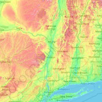
Name: Hudson River topographic map, elevation, terrain.
Location: Hudson River, New York, United States (40.65258 -74.19894 44.09099 -73.57327)
Average elevation: 974 ft
Minimum elevation: -10 ft
Maximum elevation: 4,600 ft
The source of the Hudson River is Lake Tear of the Clouds in the Adirondack Park at an elevation of 4,322 feet (1,317 m). However, the river is not cartographically called the Hudson River until miles downstream. The river is named Feldspar Brook until its confluence with the Opalescent River, and then is named the Opalescent River until the river reaches Calamity Brook, flowing south from the outlet of Henderson Lake. From that point on, the stream is cartographically known as the Hudson River. The U.S. Geological Survey (USGS) uses this cartographical definition.
Other topographic maps
Click on a map to view its topography, its elevation and its terrain.
City of Plattsburgh
United States > New York > Clinton County
City of Plattsburgh, Clinton County, New York, United States
Average elevation: 164 ft
Manhattan
United States > New York > New York County > New York
Manhattan, New York County, New York, United States
Average elevation: 52 ft
Brooklyn
United States > New York > New York
Brooklyn, Kings County, New York, United States
Average elevation: 30 ft
Buffalo
United States > New York > Erie County
Buffalo, Erie County, New York, United States
Average elevation: 607 ft
City of Schenectady
United States > New York > Schenectady County
City of Schenectady, Schenectady County, New York, 12345, United States
Average elevation: 328 ft
City of Syracuse
United States > New York > Onondaga County
City of Syracuse, Onondaga County, New York, United States
Average elevation: 564 ft
City of Yonkers
United States > New York > Westchester County
City of Yonkers, Westchester County, New York, United States
Average elevation: 190 ft
Adirondack Park
Adirondack Park, New York, United States
Average elevation: 1,217 ft
Monroe County
Monroe County, New York, United States
Average elevation: 400 ft
Saratoga County
Saratoga County, New York, United States
Average elevation: 715 ft
City of Ithaca
United States > New York > Tompkins County
City of Ithaca, Tompkins County, New York, United States
Average elevation: 640 ft
Dutchess County
Dutchess County, New York, United States
Average elevation: 587 ft
Big Indian
United States > New York > Ulster County > Town of Shandaken
Big Indian, Town of Shandaken, Ulster County, New York, 12410, United States
Average elevation: 1,762 ft
Orange County
Orange County, New York, United States
Average elevation: 636 ft
Godeffroy
United States > New York > Orange County
Godeffroy, Town of Deerpark, Orange County, New York, 12739, United States
Average elevation: 705 ft
Tompkins County
Tompkins County, New York, United States
Average elevation: 1,237 ft
Central Park
United States > New York > New York County > New York
Central Park, New York County, New York, United States
Average elevation: 85 ft
East Hampton
United States > New York > Suffolk County > East Hampton > Village of East Hampton
East Hampton, Village of East Hampton, Suffolk County, New York, 11937, United States
Average elevation: 39 ft
City of Binghamton
United States > New York > Broome County
City of Binghamton, Dickinson, Broome County, New York, 13905, United States
Average elevation: 1,053 ft
Mill Pond Park
United States > New York > New York
Mill Pond Park, Bronx County, The Bronx, New York, United States
Average elevation: 59 ft
Town of Catskill
United States > New York > Greene County
Town of Catskill, Greene County, New York, United States
Average elevation: 194 ft
Manhattan Island
United States > New York > New York
Manhattan Island, New York, United States
Average elevation: 56 ft
Upper West Side
United States > New York > New York
Upper West Side, Manhattan Community Board 7, Manhattan, New York County, New York, United States
Average elevation: 75 ft
Town of Clifton Park
United States > New York > Saratoga County
Town of Clifton Park, Saratoga County, New York, United States
Average elevation: 279 ft
The Bronx
United States > New York > New York
The Bronx, New York, United States
Average elevation: 75 ft
Westchester County
Westchester County, New York, United States
Average elevation: 312 ft
Town of Pawling
United States > New York > Dutchess County
Town of Pawling, Dutchess County, New York, United States
Average elevation: 797 ft
Town of Shelter Island
United States > New York > Suffolk County
Town of Shelter Island, Suffolk County, New York, United States
Average elevation: 10 ft
Troy
United States > New York > Rensselaer County
Troy, Rensselaer County, New York, 12181, United States
Average elevation: 449 ft
Cortland County
Cortland County, New York, United States
Average elevation: 1,486 ft
Finger Lakes National Forest
United States > New York > Schuyler County > Town of Hector
Finger Lakes National Forest, Town of Hector, Schuyler County, New York, 14818, United States
Average elevation: 1,168 ft
City of Troy
United States > New York > Rensselaer County
City of Troy, Rensselaer County, New York, United States
Average elevation: 266 ft
Tug Hill
United States > New York > Oswego Town
Tug Hill, Oswego Town, Town of Oswego, Oswego County, New York, United States
Average elevation: 358 ft
Staten Island
United States > New York > New York
Staten Island, Richmond County, New York, United States
Average elevation: 30 ft
Ulster County
Ulster County, New York, United States
Average elevation: 1,125 ft
Salisbury Mills
United States > New York > Orange County > Town of Cornwall
Salisbury Mills, Town of Cornwall, Orange County, New York, United States
Average elevation: 381 ft
Montauk
United States > New York > Suffolk County > Town of East Hampton
Montauk, Town of East Hampton, Suffolk County, New York, 11954, United States
Average elevation: 7 ft
Village of Scarsdale
United States > New York > Westchester County
Village of Scarsdale, Westchester County, New York, 10583, United States
Average elevation: 249 ft
Rensselaer County
Rensselaer County, New York, United States
Average elevation: 784 ft
Putnam County
Putnam County, New York, United States
Average elevation: 554 ft
Kingstown
United States > New York > Suffolk County > Springs
Kingstown, Springs, Town of East Hampton, Suffolk County, New York, 11937, United States
Average elevation: 39 ft
Cazenovia Lake
United States > New York > Madison County > Town of Cazenovia
Cazenovia Lake, Town of Cazenovia, Madison County, New York, United States
Average elevation: 1,224 ft
Vosburgh Swamp Wildlife Management Area
United States > New York > Greene County > Town of Coxsackie
Vosburgh Swamp Wildlife Management Area, Town of Coxsackie, Greene County, New York, United States
Average elevation: 52 ft
Town of Lowville
United States > New York > Lewis County
Town of Lowville, Lewis County, New York, 13367, United States
Average elevation: 948 ft
Oneida County
Oneida County, New York, United States
Average elevation: 1,086 ft
Lake George
United States > New York > Warren County > Town of Bolton
Lake George, Town of Bolton, Warren County, New York, United States
Average elevation: 810 ft