
Ural Mountains topographic map
Interactive map
Click on the map to display elevation.
About this map
Name: Ural Mountains topographic map, elevation, terrain.
Average elevation: 4,708 ft
Minimum elevation: 3,612 ft
Maximum elevation: 6,211 ft
As attested by Sigismund von Herberstein, in the 16th century Russians called the Ural range by a variety of names derived from the Russian words for rock (stone) and belt. The modern Russian name for the Urals (Урал, Ural), first appearing in the 16th–17th century during the Russian conquest of Siberia, was initially applied to its southern parts and gained currency as the name of the entire range during the 18th century. It might have been borrowed from either Turkic "stone belt" (Bashkir, where the same name is used for the range), or Ob-Ugric. From the 13th century, in Bashkortostan there has been a legend about a hero named Ural who sacrificed his life for the sake of his people who then poured a stone pile over his grave, which later turned into the Ural Mountains. Possibilities include Bashkir үр "elevation; upland" and Mansi ур ала "mountain peak, top of the mountain", V.N. Tatischev believes that this oronym is set to "belt" and associates it with the Turkic verb oralu- "gird". I.G. Dobrodomov suggests a transition from Aral to Ural explained on the basis of ancient Bulgar-Chuvash dialects. Geographer E.V. Hawks believes that the name goes back to the Bashkir folklore Ural-Batyr. The Evenk geographical term era "mountain" has also been theorized. (cf also Ewenkī ürǝ-l (pl.) "mountains") Finno-Ugrist scholars consider Ural deriving from the Ostyak word urr meaning "chain of mountains". Turkologists, on the other hand, have achieved majority support for their assertion that 'ural' in Tatar means a belt, and recall that an earlier name for the range was 'stone belt'.
Other topographic maps
Click on a map to view its topography, its elevation and its terrain.
Beryozovo
Russia > Khanty-Mansiysk Autonomous Okrug – Ugra > Beryozovsky District
Beryozovo, Beryozovsky District, Khanty-Mansiysk Autonomous Okrug – Ugra, Ural Federal District, Russia
Average elevation: 151 ft
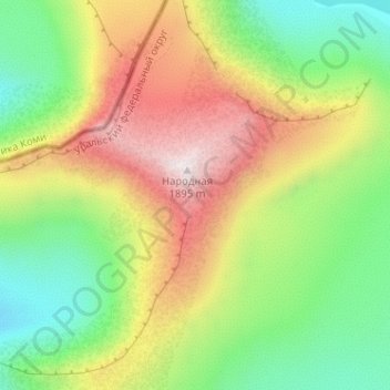
Mount Narodnaya
Russia > Khanty-Mansiysk Autonomous Okrug – Ugra > Beryozovsky District
Mount Narodnaya, Beryozovsky District, Khanty-Mansiysk Autonomous Okrug – Ugra, Ural Federal District, Russia
Average elevation: 4,715 ft
Манси
Russia > Khanty-Mansiysk Autonomous Okrug – Ugra > Beryozovsky District
Манси, Beryozovsky District, Khanty-Mansiysk Autonomous Okrug – Ugra, Ural Federal District, Russia
Average elevation: 4,285 ft