
Millcreek Township topographic map
Interactive map
Click on the map to display elevation.
About this map
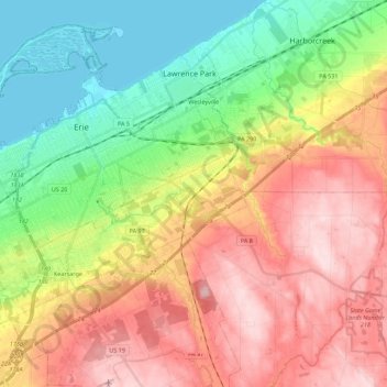
Name: Millcreek Township topographic map, elevation, terrain.
Location: Millcreek Township, Erie County, Pennsylvania, USA (42.02899 -80.21210 42.17317 -79.99002)
Average elevation: 991 ft
Minimum elevation: 564 ft
Maximum elevation: 1,483 ft
Other topographic maps
Click on a map to view its topography, its elevation and its terrain.
Presque Isle State Park
USA > Pennsylvania > Millcreek Township
Presque Isle State Park, Peninsula Drive, Millcreek Township, Erie County, Pennsylvania, 16505, USA
Average elevation: 581 ft
Eagle Peak
USA > Pennsylvania > Millcreek Township
Eagle Peak, Millcreek Township, Lebanon County, Pennsylvania, 19567, USA
Average elevation: 889 ft