
Gifu Prefecture topographic map
Interactive map
Click on the map to display elevation.
About this map
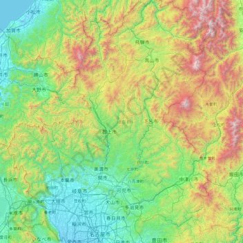
Name: Gifu Prefecture topographic map, elevation, terrain.
Location: Gifu Prefecture, Chubu Region, Japan (35.13373 136.27622 36.46507 137.65305)
Average elevation: 2,461 ft
Minimum elevation: -13 ft
Maximum elevation: 10,276 ft
Because the Mino region is surrounded by low mountains, the temperature fluctuates through the year, from hot summers to cold winters. The eastern city of Tajimi, for example, often records the hottest temperature in Japan each year and is considered to be the hottest city within Honshu boasting an average daytime high of 34.1 °C (93.4 °F) during the peak of summer. On August 16, 2007, Tajimi set the record for the hottest day recorded in Japan's history—40.9 °C (105.6 °F). Summers are hotter, as the landlocked area becomes a heat island, and the temperature rises even further when hot, dry foehn winds blow over the Ibuki Mountains from the Kansai region. The Hida region, with its higher elevation and northerly latitude, is significantly cooler than the Mino region, although there are sometimes extremely hot days there too. The Hida region is more famous for its harsh winters, bringing extremely heavy snowfall, especially in the northwestern areas. Gifu boasts a high amount of skiing locations. Shōkawa-chō, part of the city of Takayama, is up in the mountains, and its location has led it to be called the coldest inhabited place on Honshū.
Other topographic maps
Click on a map to view its topography, its elevation and its terrain.
Biratori
Biratori, Saru County, Hidaka Subprefecture, Hokkaido Prefecture, Japan
Average elevation: 607 ft
Toshima Island
Toshima Island, Maizuru, Kyoto Prefecture, Japan
Average elevation: 69 ft
Niseko
Niseko, Abuta County, Shiribeshi Subprefecture, Hokkaido Prefecture, Japan
Average elevation: 1,112 ft
Nichinan
Nichinan, Hino County, Tottori Prefecture, Japan
Average elevation: 1,906 ft
Noto
Noto, Houshi County, Ishikawa Prefecture, Chubu Region, Japan
Average elevation: 184 ft
Kitanakagusuku
Kitanakagusuku, Nakagami, Okinawa Prefecture, Japan
Average elevation: 194 ft
Watarase Usuichi
Watarase Usuichi, Tochigi, Tochigi Prefecture, 374-0112, Japan
Average elevation: 59 ft
Minakami
Minakami, Tone County, Gunma Prefecture, Japan
Average elevation: 3,350 ft
Saza
Saza, Kita-Matsuura County, Nagasaki Prefecture, 857-0322, Japan
Average elevation: 364 ft
Arita
Arita, Nishi-Matsuura County, Saga Prefecture, Japan
Average elevation: 604 ft
Sagara
Sagara, Kuma County, Kumamoto Prefecture, 868-0094, Japan
Average elevation: 1,385 ft
Nakaniikawa County
Nakaniikawa County, Toyama Prefecture, Chubu Region, Japan
Average elevation: 2,182 ft
Furuu County
Furuu County, Shiribeshi Subprefecture, Hokkaido Prefecture, Japan
Average elevation: 407 ft
Ashigarashimo County
Ashigarashimo County, Kanagawa Prefecture, Japan
Average elevation: 1,056 ft
Manazuru
Manazuru, Ashigarashimo County, Kanagawa Prefecture, 259-0201, Japan
Average elevation: 676 ft