
Naxos topographic map
Interactive map
Click on the map to display elevation.
About this map
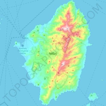
Name: Naxos topographic map, elevation, terrain.
Location: Naxos, Naxos Regional Unit, South Aegean, Aegean, Greece (36.91638 25.33292 37.20363 25.60650)
Average elevation: 367 ft
Minimum elevation: -3 ft
Maximum elevation: 3,235 ft
Other topographic maps
Click on a map to view its topography, its elevation and its terrain.
Φιλότι
Greece > Aegean > Naxos Regional Unit
Φιλότι, Municipality of Naxos and the Lesser Cyclades, Naxos Regional Unit, South Aegean, Aegean, 843 02, Greece
Average elevation: 1,581 ft
Naxos
Greece > Aegean > Naxos Regional Unit
Naxos, Municipality of Naxos and the Lesser Cyclades, Naxos Regional Unit, South Aegean, Aegean, 843 00, Greece
Average elevation: 108 ft