
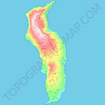
Isla Guadalupe topographic map
Interactive map
Click on the map to display elevation.
About this map
Name: Isla Guadalupe topographic map, elevation, terrain.
Average elevation: 371 ft
Minimum elevation: 0 ft
Maximum elevation: 4,213 ft
Campo Pista is located at the small airport, near the center of the island (29°01′24.04″N 118°16′21.75″W / 29.0233444°N 118.2727083°W / 29.0233444; -118.2727083, elevation:592 m, direction:05/23).[1] Airport Isla Guadalupe (ICAO Code MMGD) has a 1,200-metre-long (3,900 ft) runway. At the end of the runway near threshold 5 is the wreckage of a Lockheed Model 18 Lodestar, which overshot the runway during landing. A North American B-25J-30/32 Mitchell, BMM-3501 (c/n 44-86712), bomber wrecked on the opposite end of the runway, after suffering serious damage in trying to take-off overloaded (29°01′36.10″N 118°16′2.98″W / 29.0266944°N 118.2674944°W / 29.0266944; -118.2674944). Based on historical Google Earth imagery, this B-25 wreckage appears to have been removed from the location between October, 2005, and June, 2006.
Other topographic maps
Click on a map to view its topography, its elevation and its terrain.
Francisco Zarco (Valle de Guadalupe)
Mexico > Baja California > Municipio de Ensenada
Francisco Zarco (Valle de Guadalupe), Municipio de Ensenada, Baja California, Mexico
Average elevation: 1,260 ft
San Vicente
Mexico > Baja California > Municipio de Ensenada
San Vicente, Municipio de Ensenada, Baja California, 22900, Mexico
Average elevation: 515 ft
Ensenada
Mexico > Baja California > Municipio de Ensenada
Ensenada, Municipio de Ensenada, Baja California, Mexico
Average elevation: 604 ft