
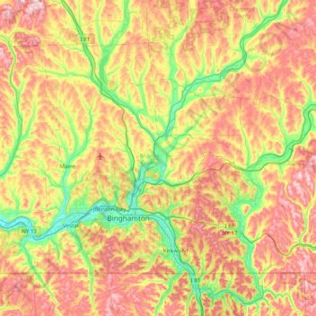
Broome County topographic map
Interactive map
Click on the map to display elevation.
About this map
Name: Broome County topographic map, elevation, terrain.
Location: Broome County, New York, United States (41.99786 -76.13017 42.41554 -75.35955)
Average elevation: 1,355 ft
Minimum elevation: 791 ft
Maximum elevation: 2,083 ft
The county's western portion is hilly, with wide valleys that accommodate Binghamton and its suburbs. In the northern portion, Interstate 81 traverses a wide glacial valley. The east part of the county is much more rugged, as the land rises to the Catskill Mountains. The terrain generally slopes to the west. The county's highest point is in the northwest of the county, a U.S. National Geodetic Survey benchmark known as Slawson atop an unnamed hill in the Town of Sanford. It is approximately 2087 feet (636 m) above sea level. An area due east on the Delaware County line in Oquaga Creek State Park also lies within the same elevation contour line. The lowest point is 864 feet (263 m) above sea level, along the Susquehanna River, at the Pennsylvania state line.
Other topographic maps
Click on a map to view its topography, its elevation and its terrain.
Manhattan
United States > New York > New York County > New York
Manhattan, New York County, New York, United States
Average elevation: 52 ft
City of Syracuse
United States > New York > Onondaga County
City of Syracuse, Onondaga County, New York, United States
Average elevation: 564 ft
Staten Island
United States > New York > New York
Staten Island, Richmond County, New York, United States
Average elevation: 30 ft
East Hampton
United States > New York > Suffolk County > East Hampton > Village of East Hampton
East Hampton, Village of East Hampton, Suffolk County, New York, 11937, United States
Average elevation: 39 ft
Central Park
United States > New York > New York County > New York
Central Park, New York County, New York, United States
Average elevation: 85 ft
City of Schenectady
United States > New York > Schenectady County
City of Schenectady, Schenectady County, New York, 12345, United States
Average elevation: 328 ft
City of Ithaca
United States > New York > Tompkins County
City of Ithaca, Tompkins County, New York, United States
Average elevation: 640 ft
Adirondack Park
Adirondack Park, New York, United States
Average elevation: 1,217 ft
Buffalo
United States > New York > Erie County
Buffalo, Erie County, New York, United States
Average elevation: 607 ft
City of Troy
United States > New York > Rensselaer County
City of Troy, Rensselaer County, New York, United States
Average elevation: 266 ft
City of Rye
United States > New York > Westchester County
City of Rye, Westchester County, New York, United States
Average elevation: 30 ft
United States of America Property
United States > New York > Dutchess County > Village of Pawling
United States of America Property, West Dover Road, Village of Pawling, Town of Pawling, Town of Dover, Dutchess County, New York, 12564, United States
Average elevation: 823 ft
Town of Catskill
United States > New York > Greene County
Town of Catskill, Greene County, New York, United States
Average elevation: 194 ft
Manhattan Island
United States > New York > New York
Manhattan Island, New York, United States
Average elevation: 56 ft
Putnam County
Putnam County, New York, United States
Average elevation: 554 ft
The Bronx
United States > New York > New York
The Bronx, New York, United States
Average elevation: 75 ft
Orange County
Orange County, New York, United States
Average elevation: 636 ft
Brooklyn
United States > New York > New York
Brooklyn, Kings County, New York, United States
Average elevation: 30 ft
Saratoga County
Saratoga County, New York, United States
Average elevation: 715 ft
Westchester County
Westchester County, New York, United States
Average elevation: 312 ft
City of Plattsburgh
United States > New York > Clinton County
City of Plattsburgh, Clinton County, New York, United States
Average elevation: 164 ft
City of Binghamton
United States > New York > Broome County
City of Binghamton, Dickinson, Broome County, New York, 13905, United States
Average elevation: 1,053 ft
Finger Lakes National Forest
United States > New York > Schuyler County > Town of Hector
Finger Lakes National Forest, Town of Hector, Schuyler County, New York, 14818, United States
Average elevation: 1,168 ft
Upper West Side
United States > New York > New York
Upper West Side, Manhattan Community Board 7, Manhattan, New York County, New York, United States
Average elevation: 75 ft
Monroe County
Monroe County, New York, United States
Average elevation: 400 ft
Dutchess County
Dutchess County, New York, United States
Average elevation: 587 ft
Ulster County
Ulster County, New York, United States
Average elevation: 1,125 ft
Godeffroy
United States > New York > Orange County
Godeffroy, Town of Deerpark, Orange County, New York, 12739, United States
Average elevation: 705 ft
Village of Scarsdale
United States > New York > Westchester County
Village of Scarsdale, Westchester County, New York, 10583, United States
Average elevation: 249 ft
Rensselaer County
Rensselaer County, New York, United States
Average elevation: 784 ft
Town of Clifton Park
United States > New York > Saratoga County
Town of Clifton Park, Saratoga County, New York, United States
Average elevation: 279 ft
Town of Sangerfield
United States > New York > Oneida County
Town of Sangerfield, Oneida County, New York, United States
Average elevation: 1,430 ft
Town of Shelter Island
United States > New York > Suffolk County
Town of Shelter Island, Suffolk County, New York, United States
Average elevation: 10 ft
Oneida County
Oneida County, New York, United States
Average elevation: 1,086 ft
Montauk
United States > New York > Suffolk County > Town of East Hampton
Montauk, Town of East Hampton, Suffolk County, New York, 11954, United States
Average elevation: 7 ft
City of Yonkers
United States > New York > Westchester County
City of Yonkers, Westchester County, New York, United States
Average elevation: 190 ft
Lake George
United States > New York > Warren County > Town of Bolton
Lake George, Town of Bolton, Warren County, New York, United States
Average elevation: 810 ft
Big Indian
United States > New York > Ulster County > Town of Shandaken
Big Indian, Town of Shandaken, Ulster County, New York, 12410, United States
Average elevation: 1,762 ft
Town of Huntington
United States > New York > Suffolk County
Town of Huntington, Suffolk County, New York, United States
Average elevation: 98 ft
Roosevelt Island
United States > New York > New York County > New York
Roosevelt Island, Manhattan, New York County, New York, 10044, United States
Average elevation: 43 ft
Cortland County
Cortland County, New York, United States
Average elevation: 1,486 ft
Graymoor
United States > New York > Putnam County
Graymoor, Town of Philipstown, Putnam County, New York, 10524, United States
Average elevation: 548 ft
Town of Vestal
United States > New York > Broome County
Town of Vestal, Broome County, New York, United States
Average elevation: 1,220 ft
Tug Hill
United States > New York > Oswego Town
Tug Hill, Oswego Town, Town of Oswego, Oswego County, New York, United States
Average elevation: 358 ft
Tompkins County
Tompkins County, New York, United States
Average elevation: 1,237 ft